 The severe storms in Tasmania over the past week are a reminder of the fragility of infrastructure on remote, wind-swept Maatsuyker Island. From the ABC News website 5th August, 2015:
Maatsuyker Island power cut: Parks staff to assess damage after lightning strike
Parks and Wildlife will send staff by helicopter to remote Maatsuyker Island off Tasmania’s south coast to assess damage from a lightning strike which has affected weather forecasting.
Weather observers have been left without power since Sunday [2nd August, 2105] after a major lightning strike knocked out the island’s main power system.
The Parks and Wildlife Service is waiting for weather to improve to send a helicopter to assess damage to the power generator.
Staff will also assess if two caretakers will remain on the island while the damage is repaired.
Forecaster Matthew Thomas said there would be no weather observations for at least two weeks.
Mr Thomas said data collected on the island provided critical information for fishermen and shipping.
“It is quite an important location for us in the south-west, it’s really our major location for marine users, providing both swell observation as well as a wind observations,” he said.
“So for any ship that is going across the south coast, out to the west coast it is very, very important.”
I regularly keep an eye on the latest Bureau of Meteorology weather observations for Maatsuyker Island here –
http://www.bom.gov.au/products/IDT60801/IDT60801.94962.shtml
Over the past few days, the website has been displaying this message –No observations were reported from Maatsuyker Island in the last 72 hours.
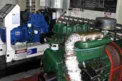
The power supply on the island is from solar panels and a diesel generator that feed a battery bank. I read that a renewable energy system consisting of wind and solar panels was installed in 2006 but the wind component was not viable and no longer exists. There are also 100kg gas bottles at each house for hot water and cooking. The Parks and Wildlife Service supplies the electricity fuel and gas, but usage must be minimised due to the very high transport (helicopter) costs.
During our stay on the island, we were always mindful of our power usage. In general, there was always plenty of power, thanks to the long sunny days of December 2011. One of the issues is trying to avoid a sudden drain of power to essential services which is why some electrical appliances (e.g. heaters) are not allowed. The power to Q2 was used for lighting and the fridge. We bought some solar-powered lamps to take to (and leave on) the island for use at night. With the long days of summer, it was easy to keep them charged.

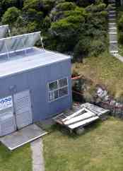
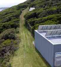
 A shed housing the generator is located a short distance from the lighthouse tower. From the photos, you can see the solar panels installed on the roof. The fuel farm, consisting of 8 tanks, is sited immediately to the north of the generator shed. Diesel is gravity fed through a raised pipe from the tanks to the generator. These photos were taken from the balcony of the lighthouse. The photo on the left is looking north, along the path from the lighthouse to the main track. The photo on the right shows the shed and steps leading from Q1 to the lighthouse.
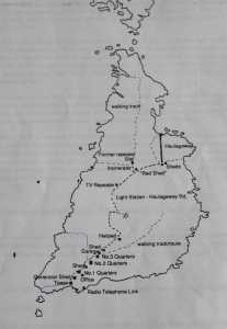
 Next to the helipad is a platform with header tanks. The fuel is pumped into the header tanks from containers flown in by the helicopter. It is then transferred to the fuel farm tanks near the lighthouse by gravity feed through a raised pipe that runs along side the road. Hopefully when you enlarge this diagram of the buildings and tracks on the island, the layout will be clear.
